 Click on satellite name, region name, or check boxes to toggle view of the Global WFABBA composite overview from the past 48 hours in a Google Earth interface. The "map" link will open the same data on a Google Map interface with fewer interactive features but greater browser compatibility. For more details continue to the bottom of the page or click question mark to the right.
Link to
temporal product in Google Earth interface.
* Application requires Google Earth 6.1 or later: available here
* Use check boxes to view fire detections from the past 48 hours.
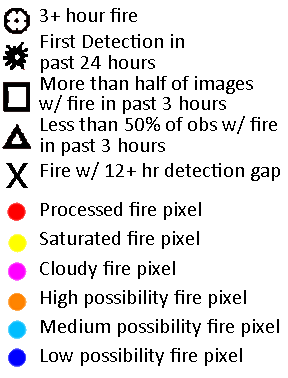
* Fires with multiple detections spanning 3 hours are the most confident detections ![]()
![]()
![]()
![]()
![]()
* The first detection of a fire can offer early warning, but if not followed by later detections it may be indicative of a small agricultural fire or a possible false-positive ![]()
![]()
![]()
![]()
![]()
* Fires with more than half of the image times with fire detections in the past 3 hours indicates a increasing confidence of an early detection of a fire ![]()
![]()
![]()
![]()
![]()
* Fires with less than half of the image times with fire detections in the past 3 hours indicates a higher likelhood the fire detection may have either been a small, short lived fire or a higher a result of short-lived conditions that may have created a false-positive ![]()
![]()
![]()
![]()
![]()
* Fires with a gap in fire detection of longer that 12 hours indicates a higher likelhood the fire detection may be due to phenomena causing a repeat false alarm since long-lived fires would not be expected to have large gaps in detection; the exception would be in areas with sparse coverage ![]()
![]()
![]()
![]()
![]()
* For most applications, low possibilty detections should not be considered fire pixels ![]()
![]()
![]()
![]()
![]()
* Use the Google navigation tools to pan and zoom to find your region of interest.
The background map is a static "blue marble" provided by Google for illustrative purposes only.
* Clicking on a fire icon will show metadata for the selected fire pixel. In some cases fire icons will be stacked as a result of multiple fire detections in the same region.
* The coverage shows the approximate extent of the WFABBA processing for each platform. Algorithm performance may be suspect in the limb region defined by the outer thick circle and thin inner circle. Detailed fire, cloud and block-out zone masks are available upon request.
* Fire symbols do not represent the size of the fire or the exact location. Navigation errors tend to increase with increasing latitude or increasing scan angle and can be on the order of the pixel size.
* MODIS - FIRMS fire symbols ![]() and
and ![]() represent MODIS-Aqua and MODIS-Terra fire detection locations. These fires were not detected with the WFABBA technique, but rather the MODIS-FIRMS technique. More information is available here and here
represent MODIS-Aqua and MODIS-Terra fire detection locations. These fires were not detected with the WFABBA technique, but rather the MODIS-FIRMS technique. More information is available here and here
* VIIRS fire symbols ![]() represent VIIRS fire detection locations. These fires were not detected with the WFABBA technique, but rather the VIIRS technique. More information is available here
represent VIIRS fire detection locations. These fires were not detected with the WFABBA technique, but rather the VIIRS technique. More information is available here