
Today
 View of the fire composite overview from today in a Google Maps interface. For more details continue to the bottom of the page or click question mark to the right.
 * Use the Google navigation tools to pan and zoom to find your region of interest.
The background map is a static "blue marble" provided by Google for illustrative purposes only.
* Use the Google navigation tools to pan and zoom to find your region of interest.
The background map is a static "blue marble" provided by Google for illustrative purposes only.
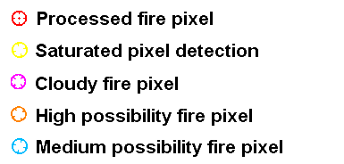
* Clicking on a fire icon will show metadata for the selected fire pixel. In some cases fire icons will be stacked as a result of multiple fire detections in the same region.
* Fire symbols do not represent the size of the fire or the exact location. Navigation errors tend to increase with increasing latitude or increasing scan angle and can be on the order of the pixel size.
* MODIS - FIRMS fire symbols ![]() and
and ![]() represent MODIS-Aqua and MODIS-Terra fire detection locations. More infomration on FIRMS is available here and here
represent MODIS-Aqua and MODIS-Terra fire detection locations. More infomration on FIRMS is available here and here
* VIIRS fire symbols ![]() represent VIIRS fire detection locations. These fires were not detected with the WFABBA technique, but rather the VIIRS technique. More information is available here
represent VIIRS fire detection locations. These fires were not detected with the WFABBA technique, but rather the VIIRS technique. More information is available here